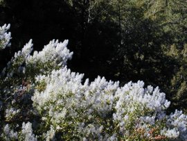
I grew up exploring the San Gabriel Mountain Range.I have backpacked into Bear Creek Wilderness on the West Fork of the San Gabriel River several times. There is a parking lot where Highway 39 meets the West Fork. You start out hiking up a paved road which goes to Cogswell Dam. After about a mile Bear Creek forks off to the north. The Bear Creek Wilderness is a unique geological area at the foot of Bear Mountain. This area is relatively flat compared to the steep surrounding terrain. Do not get the idea that this means a large flat meadow. The area has many canyons which are divided by ridges but these ridges are not on the scale of Glendora Ridge which starts in Azusa and ends above Baldy Village. 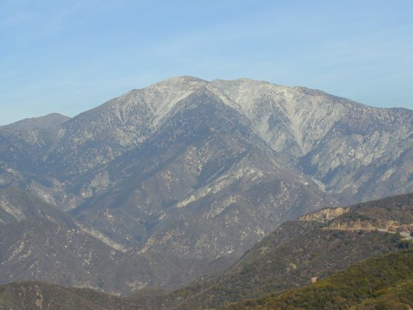
I have backpacked to The Narrows in the East Fork of the San Gabriel River many times. This is an extremely fun hike as part of the time you can hike along the old road which was washed out in flood in the late 1930's. And there is a bonus! As you walk along the old road approaching The Narrows the road ascends the mountain flank. You are at least two hundred feet above the canyon floor when you see the Bridge to Nowhere. The road continues onto the bridge but at the end of the concrete span, which was built in the early 1930's, it abruptly stops ending in the flank of a mountain. What has happened is that a tunnel that was driven through the flank and came out on the other side has collapsed on the bridge side. Once when we were in high school we decided to backpack up to Iron Fork which is a couple of miles past The Narrows. It got dark and began to rain. We had to ford the San Gabriel River in many places and we were all wet at least to mid torso. We decided to use the tunnel as a campground. At this time it was still possible to do so as there were flat areas on the tunnel floor. Now so much of the roof of the tunnel has collapsed that camping in the tunnel is not feasible. Passing beyond The Narrows you first come to Iron Fork, so called because it is at the base of Iron Mountain. I always loved Iron Fork because there was, possibly still is, a section that was carved out of solid rock creating a series of pools.
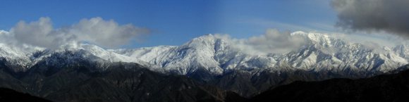
I will never forget one time when we had backpacked up to Iron Fork. It was late winter and still fairly cold. A friend, Wayne Reggitore, decided he wanted a big bonfire so he spent two or three hours collecting firewood. In a sandy protected area he built his bonfire. There was a pool that was crystal clear, about twelve feet deep, fifteen feet across and twenty feet long at the edge of the sandy area. We stripped naked and took a running leap into the ice cold water. I was sure glad we had that bonfire. When I hit the water I lost my breath, luckily no muscles cramped up. I don't remember getting out but I do know it was lickety split. In the early 1990's my uncle, Patrick Hasty and I, took a backpack trip with two of my nephews, one in junior high the other still in elementary, from Mount Baden Powell the entire length of the East Fork of the San Gabriel River. From Baden Powell we descended to Prairie Fork where the trail ended. To complete our journey we had to follow the course of the East Fork of the San Gabriel River many times having to actually walk in the river. Patrick had believed there was a trail through this section of East Fork of the San Gabriel River but any trial that had once existed was gone now. We finally made it to Fish Fork where the trail begins again and spent the night there. The next day we hiked to Iron Fork and on to The Narrows. The next day we hiked out which is the parking lot at the end of the East Fork of the San Gabriel River road. I must say my young nephews, Brad and Eddie, did just fine whereas both Patrick and I had minor injuries. Overall it was quite an experience. It could be done in two days by most able bodied men. 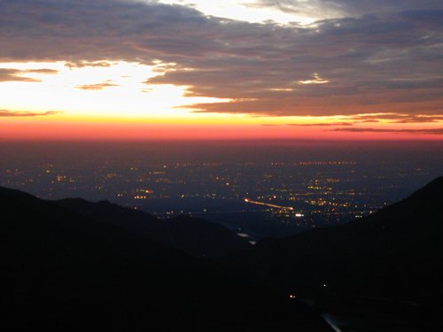 Looking down at the mouth of San Gabriel Canyon with the lights of the Los Angeles Basin at sunset I have hiked to the top of Mount Baldy three times. Twice we ascended the bowl above the Sierra Club ski hut and the other time we ascended the Devil's Backbone. All three times we went back along the Devil's Backbone. The most astonishing thing to me has always been the gnarled ancient cedar trees at the edge of the tree line. It seems they must be hundreds of years old. In my youth one night by the light of the full moon with a Santa Ana condition on display we hiked to the Sierra Club ski hut. What had been mild weather below was howling icy waves of wind at the Sierra Club ski hut. We hunkered down behind it until the sky lightened and then descended.
When I was first able to drive Highway 39 was open to Angeles Crest Highway. I enjoyed hiking on the Crest, which has the Pacific Crest Trial running along it, during that period of time. I first camped at Crystal Lake Campground in the late 1970's. At that time Crystal Lake actually was a lake and not the mud hole you find today. My grandfather, Ralph Brooks, said that the water district had drilled a tunnel under Crystal Lake for water and had caused it to drain. When we camped there in the late 1970's Crystal Lake still had a bait shop and a dock and rented row boats to row around the lake. It is too bad that the Federal Forest Service allowed the destruction of this wonderful naturally occurring small lake. In the early 1990's, before continued Federal Forest Service mismanagement caused what may become a permanent closure, we would camp at the campground at Crystal Lake. Many times we would pay the day use fee and park so we could hike up through the bowl of the Crystal Lake Amphitheater to Windy Gap. The Pacific Crest trail meets the trial that wound up through the Crystal Lake Amphitheater at the crest of the San Gabriel Mountains in the Windy Gap. A couple of times me and uncle Patrick backpacked up to Windy Gap, then up the trail to a little known or used side trail that descended on the north side of Angeles Crest to a small campground, with running water many times of the year, known as Lilly Springs. The last couple of times I tried to drive up to the road to the campground at Crystal Lake it has been blocked off. And now I can no longer drive up Glendora Mountain Road as it has been closed indefinitely. It seems that over the years more and more of the facilities and trials in the San Gabriel Mountains have been closed making it much more difficult to enjoy. 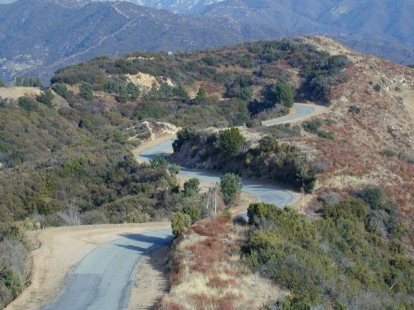
Now what is called an Adventure Pass is required to even walk a short distance from a paved road. When they started charging admission to the National Forest, which I was taught in my youth and in my naivety believed was owned by all of the American people and not just the privilege few, it caused pain to my innermost soul. Lock it up and hide it away to save it from the people that would enjoy spending a few hours living within the God's nature on Earth. Afternote: This may be the wrong place to state the obvious but the government of California and of America has been traveling down a road of fantasy that refuses to admit the reality that their current 'stewardship' of American wildlands and forests is nothing more than a real estae sales office, selling off every Americans heritage to the highest bidder in hopes for short term political prevalence. |